An In-Depth Guide to Point Cloud Data in GIS: Collection, Processing, and Applications
- Satyaranjan Swain
- Nov 9, 2024
- 4 min read
Updated: Dec 10, 2024
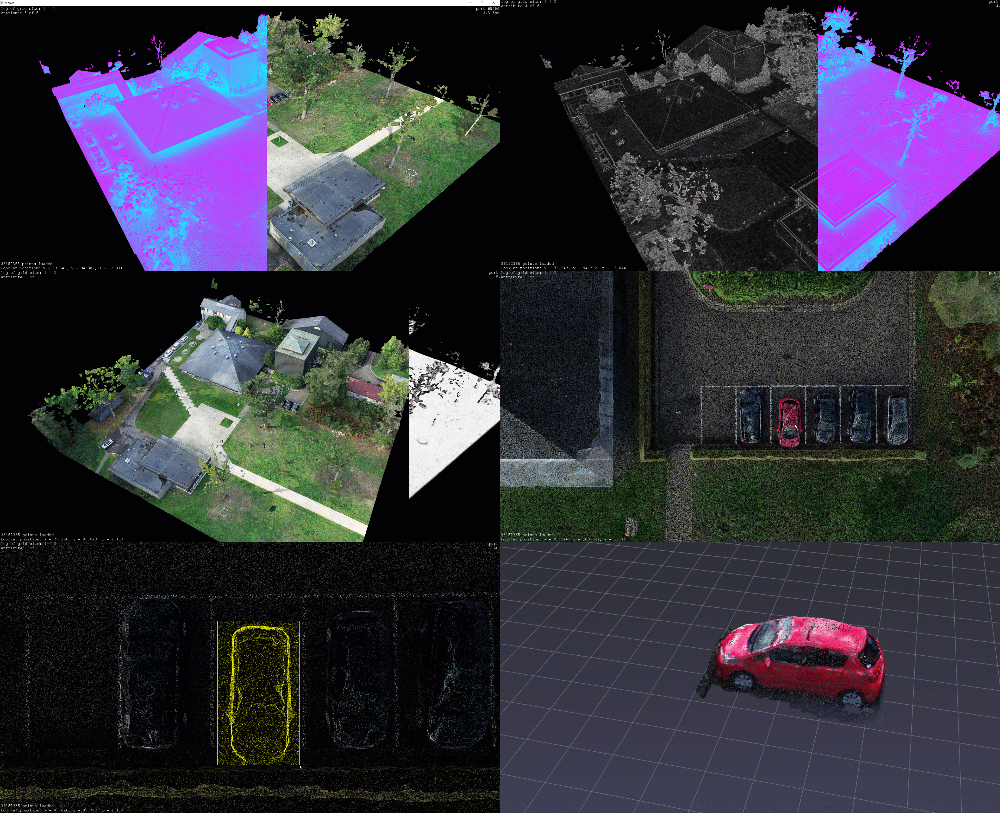
Point cloud data is revolutionizing the field of Geographic Information Systems (GIS) by offering precise 3D representations of real-world environments, crucial for detailed spatial analysis. This guide provides an extensive look at point cloud data, covering its structure, types, processing methods, and applications in GIS.

Introduction to Point Cloud Data
Point cloud data consists of millions of individual data points, each defined by X, Y, and Z coordinates that collectively represent the surface geometry of an object or landscape. This dense collection of points enables accurate 3D mapping, making it invaluable for modern GIS applications that demand spatial accuracy and detail. The evolution of point cloud technology has empowered industries from urban planning to forestry, where precise terrain and object modeling are essential.
Technical Breakdown of Point Cloud Structure and Attributes
A point cloud is made up of data points, each of which records spatial coordinates, color attributes (such as RGB), and intensity values. Attributes like density—how close or far apart the points are—define the resolution and level of detail a point cloud can provide. Higher density enables fine-detail modeling, but it requires significant storage and processing resources. Additionally, metadata, including sensor details and timestamp, is crucial for maintaining data accuracy and consistency in GIS analyses.
Point Cloud Data Collection Methods in GIS
1. Lidar (Light Detection and Ranging):
Lidar technology generates point clouds by measuring the time it takes for laser pulses to return after hitting surfaces. Airborne Lidar is effective for large-scale terrain mapping, while terrestrial and mobile Lidar are used for more detailed, localized data collection. Each type has specific applications in GIS, with airborne Lidar preferred for terrain and vegetation analysis, while terrestrial and mobile Lidar excel in building and infrastructure mapping.
2. Photogrammetry
Using overlapping aerial images, photogrammetry creates point clouds by identifying common features in multiple photographs. This method, while highly accurate, depends heavily on image quality and overlaps, limiting its precision for complex terrains but proving valuable for 3D modeling of urban areas.

3. Satellite and Drone Imagery
Satellites and drones capture images from which point clouds can be generated. Drones are widely used in GIS due to their flexibility, offering high-resolution data for smaller areas. Satellite data, though less detailed, is beneficial for broader regional analysis.
Classifying Point Cloud Data Types for GIS Applications
Point clouds are classified based on their dimensions, source, and method of collection.
2D vs. 3D Point Clouds: While 2D clouds are simple, 3D point clouds provide elevation data, essential for topographic and environmental analysis.
Ground vs. Non-Ground Points: Differentiating ground and non-ground points helps isolate natural features from man-made structures, useful in environmental studies and urban planning.
Static, Mobile, and UAV Point Clouds: Data collection mode impacts applications, with static points typically used for small, fixed areas, and mobile/UAV data suitable for dynamic, broader mapping tasks.
Data Processing Techniques for Point Clouds
The raw data in point clouds requires processing to be useful in GIS.
Preprocessing involves noise removal, outlier filtering, and alignment to ensure accuracy.
Segmentation and Classification separate objects, such as vegetation, buildings, and roads, and can be enhanced by machine learning for automated feature recognition.
Surface Modeling: Converting point clouds into Digital Surface Models (DSM) or Digital Terrain Models (DTM) provides actionable insights for urban planning and environmental management.
Technical Methods of Analyzing Point Cloud Data in GIS
Point clouds in GIS facilitate various types of analyses, from elevation and slope calculations to vegetation metrics. For example:
Terrain Analysis: Point clouds provide detailed elevation data for creating slope and aspect maps.
Forestry: Canopy height and tree volume estimation are possible through precise measurements of vegetation points, assisting in biomass and carbon calculations.
Change Detection: Comparing point clouds over time enables tracking landscape changes, helping in land-use monitoring and infrastructure maintenance.

Point Cloud Data Applications and Use Cases in GIS
Point cloud data has broad applications across various GIS domains, such as:
Infrastructure and Urban Planning: Used in creating 3D city models and mapping utilities, assisting planners in designing sustainable cities.
Environmental Monitoring: Effective for monitoring forests, measuring tree heights, and detecting environmental degradation.
Disaster Management: During natural disasters, point clouds aid in flood modeling, landslide detection, and damage assessment, allowing better emergency response planning.

Standards and Data Formats for Efficient Point Cloud Handling
Standard formats for point cloud data ensure compatibility and data integrity.
LAS and LAZ: These are widely used due to efficient storage and classification capabilities, particularly useful for large datasets in GIS.
PLY and E57: Other common formats for interoperability and data exchange. The ASPRS LAS format, specifically, offers classification codes that aid in organizing and interpreting point clouds, while new open data initiatives expand accessibility to quality point cloud datasets for public and professional use.
Future of Point Cloud Technology in GIS and Data Analysis
The future of point cloud technology in GIS is exciting, with developments in real-time processing and AI-enhanced feature extraction.
Real-Time Processing: Improvements in hardware and algorithms are enabling real-time point cloud analysis, especially beneficial for infrastructure monitoring and autonomous systems.
AI and Machine Learning: Integrating AI for feature recognition is streamlining classification and making complex analyses faster and more accurate.
Augmented Reality (AR) and Virtual Reality (VR): AR and VR applications are beginning to use point clouds for immersive environments in fields like urban planning, training, and interactive GIS modeling.
Conclusion: Leveraging Point Cloud Data for Advanced GIS Analysis
Point cloud data is a powerful resource in GIS, offering unprecedented levels of detail for terrain, infrastructure, and environmental analysis. As technology advances, point clouds are set to become even more integral to GIS, enabling real-time, precise, and comprehensive spatial analyses. For GIS professionals and beginners alike, understanding and utilizing point cloud data opens up new possibilities in the geospatial field.

.png)


Comments